Overview
Groundwater is the water located in the saturation zone of the Earth's crust, which moves through soil pores or fractures under the influence of gravity or hydraulic pressure. An aquifer is an underground layer of premeable rock or sediment that is saturated with water and allows for economically feasible groundwater extraction.
- In Estonia, the volume of groundwater is estimated to be around 2000 km3. It is potable and accessible from almost everywhere in the country.
Groundwater resources and balance
Groundwater resource represents the calculated volume of groundwater that can be used while preserving optimal groundwater conditions and ensuring sustainable resource management.
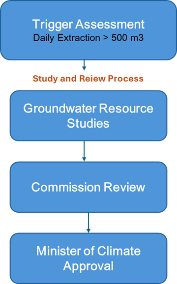
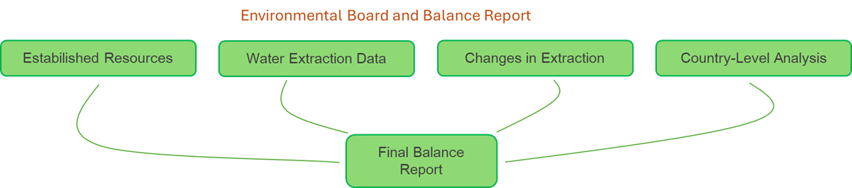
In Estonia, groundwater resources must be assessed if the planned groundwater use in the area is forseen to exceed 500 m3 per day. Estonian Environmental Agency prepares a balance sheet of Estonian groundwater resources, groundwater abstraction within these resources and calculates the free groundwater volume available for use. The more detailed logic for evaluating groundwater resources in Estonia is illustrated in the flow diagrams below.
Groundwater balance reports (in Estonian):
The status of groundwater bodies in Estonia
Estonia maintains 31 distinct groundwater bodies under regular monitoring. The chemical and quantitative status for each groundwater body is assessed on a six-year cycle. The latest status assessment was carried out in 2020 by the Estonian Geological Survey, resulting in the following summary for Estonia:
- 23 groundwater bodies are in good status: 74%
- 8 groundwater bodies are in poor status: 26%
The sources of pollutants in Estonian groundwater can be very different. It could be induced due to natural processes, for instance, the deep aquifers of the Cambrian-Vendian Voronka can mix with saltier aquifers, that could increase the chloride ion concentrations in groundwater. On the other hand, the presence of pollutants in groundwater can be caused by human activities, primarily due to intensive groundwater extraction, oil shale mining and agriculture from which the concentrations of pollutants (chloride, sulfates, ammonium, etc.) in groundwater can be higher than permitted.
More information on Estonian grounwater body status objectives and assesment methodology:
- Grounwater body status is assessed in Estonia acoording to the Guidance Document No. 18 under the Common Implementation Strategy for the Water Framework Directive
- The objectives for achieving optimal groundwater body status are outlined in European Parliament and Council Directive 2000/60/EC
- The status of groundwater bodies can be examined in more detail using the map collection below and by reading the status assessment report from 2020 (in Estonian).
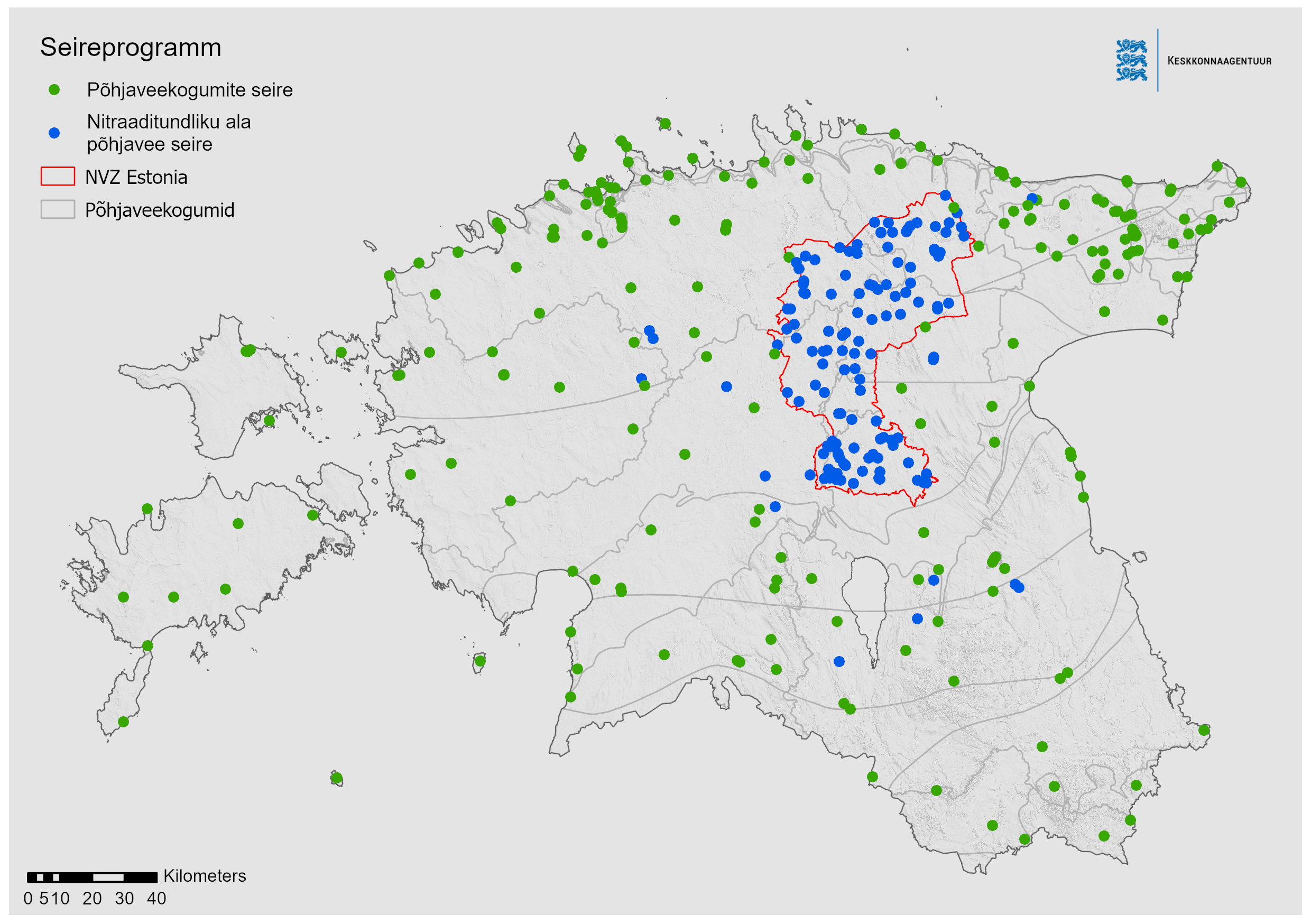
Groundwater monitoring and nitrate vulnerable zones in Estonia
Estonian national groundwater monitoring is dividend into three parts:
Quantitative monitoring
-
~245 monitoring stations, monitoring frequency ranging from monthly to daily (12-365 times annualy). Measurements are carried out manually or with an automatic water level sensor.
Chemical monitoring
-
~ 230 monitoring stations, monitoring frequency once a year. Monitoring of hazardous substances rotates according to the monitoring plan
Groundwater monitoring in Nitrate vulnerable zones (NVZ)
- The core monitoring network with 54 monitoring stations, monitoring frequency four times a year
- The support monitoring network with 58 monitoring stations, monitored once in a year
- Reference samples are taken from 7 springs and 7 wells located outside NVZ areas once in a year
Groundwater monitoring is carried out by the Estonian Environmental Research Centre (EKUK), who prepares a consolidated groundwater monitoring report based on monitoring data every year.
Monitoring data and reports are available from the KESE environmental monitoring database for public access.
Groundwater body monitoring reports (in Estonian):
- NEW! 2024 groundwater bodies monitoring report
- 2023 groundwater bodies monitoring report
- 2022 groundwater bodies monitoring report
- 2021 groundwater bodies monitoring report
More information
- Borehole registry operations
-
Answers to frequently asked questions about wells can be found on the Environmental Agency’s website (in Estonian).
A drilled well may be established by an entrepreneur or person holding the appropriate activity permit. Holders of permits for hydrogeological work.
For borehole registry operations, please contact customer support: @email