Overview
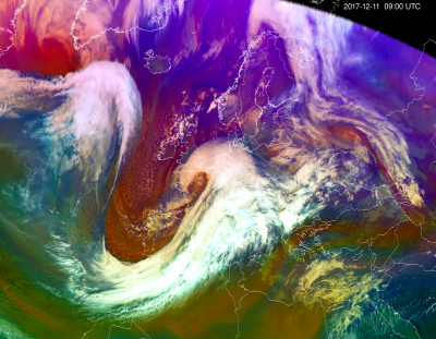
Meteorological satellite data is a modern source of information for assessing weather conditions and for short-term weather forecasting.
The Environment Agency ensures the availability of EUMETSAT and ESA satellite data, including the operational processing and use of data in the operational work of the Estonian Environment Agency and other institutions.
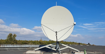
The satellite data reception system managed by the Estonian Environment Agency consists of two antennas located at the Tallinn-Harku aerological station and the Tartu-Tõravere actinometry station.
Processed satellite images are publicly available with a one-hour time interval. The Estonian Environment Agency also creates animations from satellite images for use in television weather reports.
Internal users:
- Weather forecasters at the Estonian Environment Agency use visualized satellite data to analyse weather situation, track clouds movement,prepare high-impact weather warnings and forecasts.
External users:
- Users of the website (Estonian Environment Agency | WEATHER).
- Users of the ILM+ mobile application.
- Customers, who receive processed satellite data via solutions developed according to their needs.
More information
- References
International cooperation
Estonian Environment Agency participates in the international working group of Nordic satellite specialists NORDSAT, EUMETSAT STG-OPSWG and in the MTGUP working group. For in-house use of the NWCSAF/GEO software (https://www.nwcsaf.org/) developed by EUMETSAT and cooperation partners, the Estonian Environment Agency has signed the license agreement for the use of NWCSAF Software with AEMET (State Meteorological Agency of Spain).
To ensure a high-quality sea-ice information service, the Estonian Environment Agency signed the RCM Augmented Access End-User Licence Agreement with the Government of Canada for internal use of data from the RCM (Radarsat Constellation Mission) commercial satellite imagery.