Overview
Estonia’s marine area is located in the northeastern part of the Baltic Sea and includes parts of several major Baltic Sea basins, each with different natural conditions and levels of human impact: the Gulf of Finland, the Northern Baltic Proper, and the Gulf of Riga, including Väinameri area.
The Baltic Sea is a semi-enclosed sea with slow water exchange, which limits its ability to recover from pollution and impact. Its fragile marine ecosystem depends not only on natural factors but also on human activities – both direct and indirect – within the surrounding catchment area. As a result, the sea is vulnerable to pressures such as nutrient loading, hazardous substances, and biodiversity loss. To protect and restore the Baltic Sea, the countries around it work together through international cooperation.
Coastal water status
The status of coastal waters is assessed in accordance with the Water Act and EU Water Framework Directive (2000/60/EC). The overall status is based on assessment of ecological status and chemical status of water bodies.
Depending on the extent of human impact, the ecological status of surface water bodies (including coastal water bodies) is assessed using a five-class scale from high status, where the effects of human activity are absent or negligible, to bad status, where biological quality elements show severe deviation from reference conditions or where aquatic life is absent.
The chemical status of a water body is assessed using a two-class system: good status – the concentration of priority substances is below the environmental quality standards set for surface waters; failing to achieve good status – the concentration of one or more priority substances exceeds the applicable environmental quality standards.
More information
- Status of coastal water bodies
-
The updated status information of surface water bodies, including coastal water bodies, and an interactive map are available under the surface water status section:
- Status of surface water bodies (in Estonian)
- Status of surface and groundwater – interactive map (in Estonian)
Read more:
- Water Act (in Estonian)
- Surface water
- Surface water | Ministry of Climate
- Marine monitoring
-
Marine monitoring (in Estonian)
- Marine data and reports
-
Estonian environmental monitoring database KESE (in Estonian) – Marine monitoring data and report.
More information:
- Pollution loads
-
- Assessment (in Estonian) of nutrient, organic matter, and heavy metal loads from rivers discharging into the Baltic Sea, unmonitored coastal areas, and point sources.
- Marine Strategy Framework Directive
-
The Marine Strategy Framework Directive (MSFD (in Estonian)), adopted in 2008 as Directive 2008/56/EC of the European Parliament and of the Council, establishes the obligation for EU Member States to achieve or maintain Good Environmental Status (GES) of their marine waters by the year 2020. EU Member States are required to carry out a series of actions to develop a marine strategy for the relevant marine region.
The implementation of the marine strategy takes place in six-year cycles. Each cycle includes an assessment of the state of the marine area, the development and subsequent revision of a monitoring programme, and the creation, implementation, and updating of a programme of measures.
At the initiative of the Ministry of Climate, thematic assessment reports and a summary report on the environmental status of Estonia's marine area are being compiled. These provide an overview of the current state of the marine environment and the pressure factors affecting it.
The Estonian Environment Agency is responsible for submitting the reports and related metadata to the European Commission via the central data repository of EIONET (European Environment Information and Observation Network).
- Map
-
To view the map layers, you can use one of the following open-source software options:
The map layers can be downloaded from the environmental portal's map application (in Estonian).
- Flood risk prevention and mitigation, warning systems
-
As a result of the project, flood risk monitoring, forecasting, and warning systems will be developed to prevent and mitigate flooding, which will, in the long term, help increase resilience to climate change. The project includes studies to identify the best preventive measures for risk areas and awareness-raising activities for flood risk prevention.
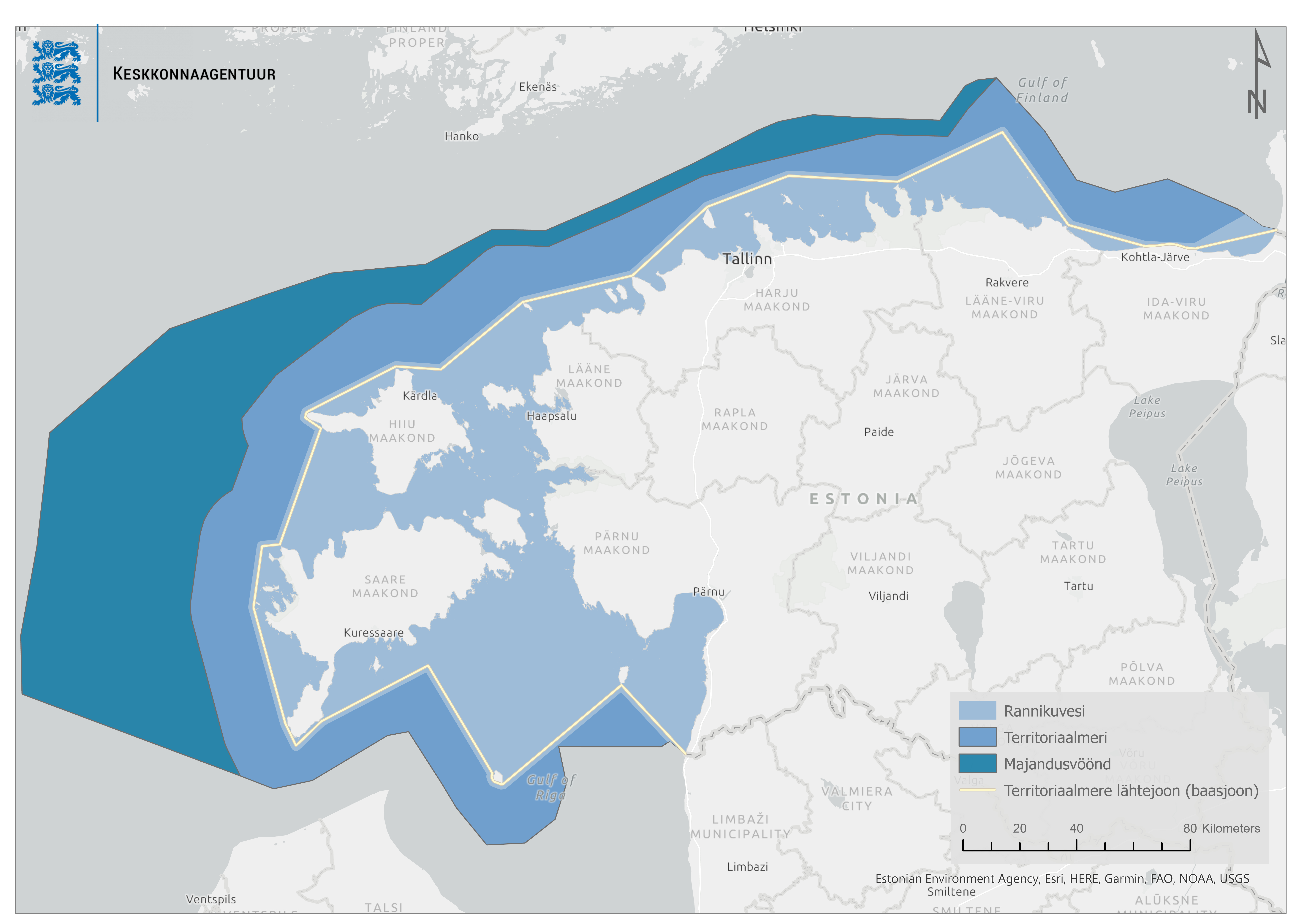
Definitions
According to the Maritime Boundaries Act (RT I 1993, 14, 217), the Estonian maritime area is divided into internal sea, territorial sea and exclusive economic zone. In addition, according to the EU Water Framework Directive and Estonia’s Water Act (§ 9), the term coastal water refers to surface water on the landward side of a line, every point of which is at a distance of one nautical mile on the seaward side from the nearest point of the baseline from which the breadth of territorial waters is measured.
- Internal waters – the marine area located between the baseline of the territorial sea and the coastline.
- Baseline of the territorial sea – an imaginary line that connects the outermost seaward points of the mainland, islands, islets, rocks, and other natural features protruding above the water, and used to measure the breadth of the territorial sea.
- Territorial sea – the marine area adjacent to internal waters, extending up to 12 nautical miles from the baseline.
- Exclusive Economic Zone (EEZ) – a maritime area beyond and adjacent to the territorial sea, where the coastal state has sovereign rights for the purpose of exploring, exploiting, conserving, and managing natural resources. The extent and boundaries of EEZ are established through agreements with neighbouring countries and in line with international law.
Related references:
Hydrological monitoring of coastal waters

Hydrological and meteorological monitoring is conducted along Estonia’s coastline. Observations are carried out 15 coastal sea level monitoring stations and include measurements of:
- Water level
- Water temperature
- Air temperature
- Precipitation
- Wind speed and direction
The latest real-time monitoring data from these stations can be found on the Estonian Environment Agency’s weather portal: ilmateenistus.ee.
Raw monitoring data is provided as open data (in Estonian) in JSON format, includes measurements recorded hourly and updated once a day. The available datasets currently include:
- Water level (average, minimum, and maximum)
- Water temperature (average, minimum, and maximum)
The data is available starting from 2023, but there are plans to make the entire historical dataset publicly accessible in the future.